↓
 

Daphne Land Surveying

...a Brandon Bailey, PLS website.

Daphne Land Surveying - Brandon Bailey header
Daphne Land Surveying
  • Home
  • Land Surveying
  • ALTA Title Survey
  • Boundary Survey
  • Construction Survey
  • Drone LiDAR Mapping
  • Lot Survey
  • Elevation Certificate | Flood Survey
  • Flood Survey
  • Contact Us
Home - Page 2 << 1 2 3 4 5 6 >>

Post navigation

← Older posts
Newer posts →

What You Need to Know About Land Surveying

Daphne Land Surveying Posted on January 24, 2017 by AdminDaphneLSMarch 9, 2020

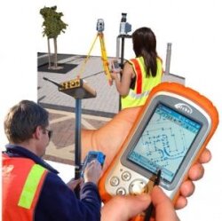
land surveying for Center Parcs "De Maasvallei" by Johan PaquayLand surveying is the art and science of accurately measuring parcels of land. Measurements such as dimensions, lengths, boundary lines, including structures within the area are all precisely determined through a land survey.

These measurements are used to establish land maps, boundaries for ownership or for governmental purposes. It is a detailed study of every physical and cultural property of the land, whether above or beneath it, to illustrate it in usable form.

Data is gathered through observations, research, field measurements, and data analysis for establishing property boundaries. Records from previous surveys and government records will strengthen the reports made after the survey.

A land survey is classified according to the purpose or why the survey is being performed. Some of the common types of land survey are boundary surveys, topographic surveys, partition or subdivision surveys, flood elevation survey, property line adjustment survey, and extended title insurance coverage survey.

 Other services such as mapping, construction layout surveys, judicial surveys, registered land surveys are all part of land surveying. It is an essential element in every development of the environment especially in the fields of construction, transport, communication, mapping, and most especially in the definition of legal boundaries for ownership.

The key component in the field of land surveying is the land surveyor. A land surveyor is a person that takes charge of every activity that transpires during a land survey.

It is the surveyor who makes the research and data gathering and even interpretation and analysis of all data wherein translation of all data gathered is crucial and should be checked, attested, and sworn in the law to be true and correct.

It is important then for you to choose a land surveyor with the highest degree of expertise and who can assume responsibility for the complex tasks at hand.

It should be emphasized that only a surveyor who has knowledge of the elements of geometry, trigonometry, engineering, mathematics, physics, and the law are expected to have the best land survey outcomes.

Land surveying is a profession as old as the Egyptian times yet its importance to the human race still lives on. It is the best method to settle disputes over land ownership, it gives a clear picture of what buildings are suited to be constructed in a given land area, and it’s a convenient way to determine the exact dimensions of real estate to be purchased or sold.

Optimum potential of the land you own can only be defined once you have a land survey. Whether you are planning to put it on the market, or should you want to use it for commercial purposes, a land survey must back you up if ever questions regarding everything about the land arise.

Land surveying will provide a sense of security and peace of mind to every land owner and even to the future buyers.

Land surveying will always be an integral part in protecting real estate and upholding of laws governing the utilization and distribution of your land assets.

Call Daphne Land Surveying today at (251) 270-4140  or fill out a contact form request for more information concerning your land surveying needs.

Posted in blog, land surveying | Tagged boundary surveying, boundary surveying daphne al, Land Surveying, land surveying daphne al, land surveyor, Land Surveyor Daphne AL

Land Surveyors: Leaving Their Marks

Daphne Land Surveying Posted on December 15, 2016 by AdminDaphneLSMarch 9, 2020

Men and women who combine their sense of adventure, their love of technology, and also their talents in making things happen with their desire to leave a lasting impression are the people who joined the ever expanding realm of land surveying.

land surveyorsLand surveying is likely one of the world's most vital occupations. It's the only job qualified to form new property boundaries. Moreover, land surveyors also play a significant part in the construction of incredible architectural accomplishments – from the historical achievements that are ages old to the impressive buildings today. As a matter of fact, three of the gents on Mount Rushmore are land surveyors themselves. Geographic Information System or GIS experts and staff rely upon surveyors for mapping details. The task of your land surveyor has shaped the world as we know it; and it all starts off with small survey markers. It might be merely a small orange survey marker, but this mark is one of the millions that the surveyor uses to take detailed measurements that would become maps which will someday become amazing buildings, new roads, master planned communities, or entire cities – and in each step along the way is a surveyor.

Land surveyors specialize in many positions:

Photogrammetric surveying In the Office, photogrammetric surveyors deal with cutting-edge software and state of the art machine. Boundary Surveying These are land surveyors who do in depth reference research studying maps and boundaries spanning centuries.

Construction Surveying Within the area, construction surveyors are the power behind any growth; these people team up with engineers to ensure that the structures are constructed within its area and coincide with the type of land where it's built on.

Hydrographic surveying Hydrographic surveyors take their work to the lake or sea, determining depths, borders, and a lot more. Geodesy involves surveying where you can acquire specific dimensions for satellite. Land Surveyors may also find themselves inside the court room. They also perform a vital role in providing expert testimonies with regards to boundaries or even in assisting crime scene cases which involves land.

Qualifications of land surveyors

With merely a high school diploma, anyone can begin as a surveyor, an on the job training that would last for just six weeks, field training, and union apprenticeship. However, a lot of land surveyors are degree holders. Local community universities may offer programs or a two year comprehensive program in land surveying. Incomes tend to be greater than average career fields that need a 4 year college diploma or if these people acquire a degree or higher, they could begin management or one of the many specializations.

Posted in land surveying, land surveyor | Tagged daphne land surveying, daphne land surveyor, Land Surveying, land surveying daphne, land surveying daphne al, land surveyor, land surveyor daphne, Land Surveyor Daphne AL, land surveyors

Flooding From Excessive Rain Downstream From Earth Dams

Daphne Land Surveying Posted on November 8, 2016 by AdminDaphneLSMarch 9, 2020

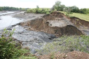
rose hill dam failure - floodingAn article from the Daily Republic in South Dakota talks about an earthen dam that recently failed there due to a 9-inch rainfall event on July 29th of this year.

This rainfall event “overwhelmed its capacity” causing the failure of the earth dam.  There was no report of injury downstream of the dam. This dam was built in 1935, as were a number of them during the Work Programs after the Great Depression.

A Department of Game, Fish and Parks Engineer said that they “were satisfied with the condition of the dam” during inspections in 2007 and again in 2008 and that the dam breach “was caused by an extraordinary natural event and not by any structural weakness in the dam.” (Photograph by Laura Wehde/The Daily Republic)

Earth dams are almost too numerous to count around the country. In fact, you probably live a lot closer to one than you might think. A large number of dams were built over 70 years ago and, in many cases, the owners of the dams are different than when they were built. This makes maintenance and inspection of the dams less regular.

FEMA estimates “there are over 80,000 dams in the United States”, and that approximately “one third of these pose a ‘high’ or ‘significant’ hazard to life and property if failure occurs.”

In the countries worst dam failure disaster, the South Fork dam failure in May of 1889 killed over 2200 people (almost half of which were under 20 years old) in the town of  Johnstown, PA.

This is known as the “Johnstown Flood.”  A 37-foot high wall of water hit Johnstown, located 9 miles downstream from the dam. The entire city was almost destroyed, including 1600 homes and 280 businesses.

After the failure of the St. Francis Dam in California in March 1928, legislation was enacted in and around California. This, and other later legislation led to life-saving advance warning when the Baldwin Hills dam near Los Angeles, California failed on December 14, 1963.

Only 5 individuals were killed because of the advance warning which enabled the evacuation of approximately 16,500.

Even though there have been far less loss of lives in the United States from dam failures since the 1970’s, reports that…

there were 132 dam failures and 434 “incidents” between January 2005 and January 2009.

Of course, I should note that the failure of the earthen levees near New Orleans, LA during and after Hurricane Katrina are purported to be responsible for killing more than 1000 people.

The KaLoko Dam on the Island of Kauai, Hawaii failed in March of 2006 killing 7 people. In November of 2008, the developer, James Pflueger, was indicted for manslaughter and reckless endangerment in relation to the dam failure. The county of Kauai and the State of Hawaii paid out over $9 Million in settlement of lawsuits after the failure.

Cause of Dam Failures

Heavy rains cause overtopping, which is by far the most common cause of dam failures. Dam spillways and structures are typically not designed for more than a 1-percent chance (aka 100-year) storm event.

When a rain event exceeds this, the water begins to travel outside of the control spillway. This leads to erosion of the soil on the dam from the excessive amount of water traveling over it.

It is also possible for overtopping to occur from smaller rain events because of debris blockage of the outlet structure or spillways or because of settlement of the dam crest.

Foundation defects, including settlement and slope instability, cause about 30% of all dam failures.

Seepage or Piping is the cause of another 20% of U.S. dam failures. Piping is the internal erosion caused by seepage under and through the dam. It often occurs around structures such as pipes through the dam and spillways.

Seepage can also be caused by animals burrowing in the dam, by roots of trees growing on the dam, and through cracks in the dam.  All earth dams have seepage resulting from water permeating slowly through the dam and its foundation.

But this seepage must be controlled or it will progressively erode soil from the embankment or its foundation, resulting in rapid failure of the dam.

What Should You Do To Protect Home?

Since the failure of a dam causes excessive flooding, one of the best courses of action is to avoid building in a flood zone, unless you elevate and reinforce your home. You should have your area investigated for flood determination or dam failure.

Do you live downstream from a dam? Is the dam a high-hazard or significant-hazard potential dam?

To find out, contact your state or county emergency management agency and/or visit the National Inventory of Dams. There are around 2,228 dams on the National Inventory in Alabama. Of those, 636 are listed as high or significant hazard potential dams.

If you live downstream from one of these dams, find out who owns the dam and who regulates the dam. This information should also be available from the National Inventory of Dams.

Next, find out if there is an Emergency Action Plan in place. Again, consult your state or county emergency management agency. (Alabama Emergency Management Agency)

Strangely enough, Alabama is the only state in the United States that has not passed dam safety legislation.

If you want help with investigating a piece of property you are considering purchasing or of one you already purchased, please call Daphne Land Surveying today at (251) 270-4140 or better yet send us a contact form request.

Posted in elevation certificate, flooding, land surveyor | Tagged dam failure, earth dam, flood, flooding

Post navigation

← Older posts
Newer posts →

Contact Us Now

    Categories

    • blog
    • elevation certificate
    • flooding
    • GPS
    • land surveying
    • land surveyor
    © Copyright Daphne Land Surveying
    Daphne, Alabama 36526
    Phone: (251) 270-4140

    Privacy Policy | Terms of Use

    Web Development and SEO by:
    AuburnBusiness.com

    The owner of this website, USA Surveying & Engineering, LLC., provides coordination of professional land surveying and engineering services in all 50 states. The professional surveying and engineering services provided to you will be conducted by fully licensed professionals in your state.

    Privacy Policy
    ↑