
Topo Survey Before a Retaining Wall: The Data Contractors Should Not Guess
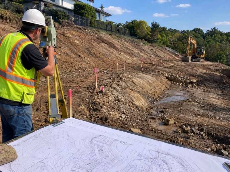
Contractors building retaining walls need accurate information about the ground. Guessing about slope angles, soil depth, or water flow leads to failed walls and expensive repairs. A topographic survey gives contractors the exact data they need before they start digging. The survey shows ground height, slope angles, and soil conditions across the wall site. Without this information, contractors risk building walls in the wrong places or making them the wrong height. A topo survey takes the guesswork out of retaining wall construction.
Ground Height Changes Tell the Contractor Where to Build
A retaining wall holds back soil on a slope. The contractor needs to know exactly how high the slope is on both sides. A topo survey measures the ground elevation at many points. It shows the height difference between the top of the slope and the bottom. This height difference tells the contractor how tall the wall needs to be.
Contractors cannot guess at these heights. A wall that is too short fails because soil spills over the top. A wall that is too tall costs much more to build and wastes materials. A topo survey removes this guessing. The surveyor marks the exact elevation where the wall base sits and where the top of the wall should be.
The survey also shows whether the slope is straight or curved. Some slopes have benches or flat spots partway up. A topo survey reveals these features. Contractors use this information to plan how the wall follows the ground instead of fighting it.
Soil Type Transitions Affect Foundation Depth
Soil changes as you dig deeper. Near the surface might be soft dirt. Lower down might be harder clay or sandy soil. Even deeper might be rock. A topo survey does not just measure height. It also maps visible soil transitions across the site.
Contractors need to know where these transitions occur. A wall foundation must sit on solid ground, not soft soil. If the contractor digs down and suddenly hits rock at two feet, the foundation depth changes. If they encounter only soft soil at four feet, they might need to dig deeper.
A topo survey shows these transitions before digging starts. The surveyor notes where the ground appearance changes. They mark areas that look like they might hold rock or different soil types. This information lets contractors plan their foundation depth and avoid surprises during construction.
Water Flow Patterns Prevent Wall Failure
Water is the main enemy of retaining walls. Water pressure behind the wall pushes it forward. Water that sits in soil makes it heavier and more likely to slide. A topo survey shows the contractor where water collects and how it flows across the site.
The survey reveals low spots where water gathers. It shows slope angles that direct water toward or away from the wall location. It marks existing drainage paths so contractors understand where water naturally goes. This information lets contractors plan drainage behind the wall before the wall is built.
Contractors need to install drainage systems to prevent wall failure. These systems work best when they are positioned correctly. A topo survey shows the contractor exactly where to place drains so they actually collect water. Without this information, a contractor might install a drainage system in the wrong spot where water bypasses it.
Slope Angles Define Wall Height and Reinforcement
The angle of a slope determines how much pressure it puts on a wall. A steep slope creates more pressure than a gentle slope. Contractors need to know the exact slope angle so they can design the wall correctly.
A topo survey measures these angles precisely. The surveyor creates a profile map that shows the slope angle at different points. Contractors use this profile to decide wall height, thickness, and whether the wall needs reinforcement. A gentle slope might need a simple wall. A steep slope might need a much stronger wall or special bracing.
Guessing at slope angles costs money. A contractor might build a weak wall that fails later. Or they might build an overly strong wall that wastes materials. Accurate slope data from a topo survey prevents both problems.
Rock and Hard Soil Change Excavation Plans
Some sites have exposed rock or hard soil near the surface. These materials are difficult and expensive to excavate. A contractor needs to know where they are so they can plan their equipment and schedule.
A topo survey shows where rock might be present. The surveyor notes exposed rock faces or areas where rock is visible at the ground surface. They mark soil conditions that look different from regular dirt. This information helps contractors plan whether they need specialized equipment like a jackhammer or rock breaker.
Without this information, a contractor might arrive with standard digging equipment and discover they cannot dig through rock. This creates expensive delays and equipment changes. A topo survey prevents these surprises by showing the contractor what they will encounter before they start work.
Frequently Asked Questions
What data from a topo survey helps retaining wall contractors most?
Ground elevation, slope angles, soil transitions, water flow patterns, and rock locations. These specifics tell contractors how tall to build the wall, how deep to dig the foundation, and where to install drainage.
Why cannot contractors just walk the site and estimate slope angles?
Walking a site and eyeballing slopes is unreliable. Contractors miss small changes that matter for wall design. A topo survey measures these angles with precision that eyes cannot achieve.
Does a topo survey show where underground utilities are located?
A topo survey marks utilities that are visible above ground, like pipes or cables. But utilities buried underground require separate utility locating services.
How much do contractors rely on topo survey data for wall planning?
Contractors base their entire wall design on this data. Wall height, foundation depth, drainage location, and reinforcement needs all depend on accurate elevation and slope information from the survey.
Can a contractor build a retaining wall without a topo survey?
Technically yes, but they would be guessing. Without survey data, they risk building a wall that fails, is undersized, or costs far more than necessary.