
Do You Need a Topographic Survey Before Adding a Pool, Deck, and Extensions to Your Home?
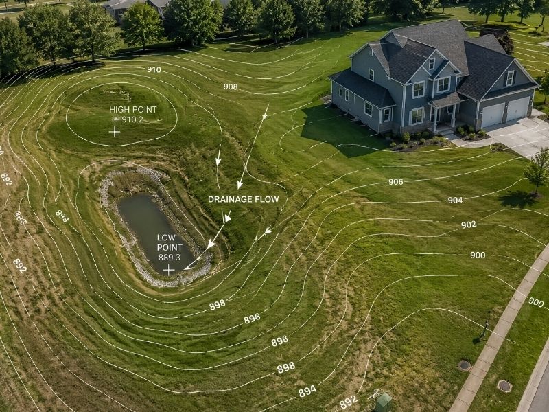
Most permit rejections come down to one thing: missing site data. A contractor estimates grades by eye. A designer draws plans without knowing where the drainage goes. Then the permit office kicks it back. Or worse, construction starts and water runs the wrong way.
A topographic survey stops that before it starts. For pools, decks and home additions, it’s often the difference between a smooth approval and an expensive rework.
What Is a Topographic Survey?
A topographic survey maps the physical features of your property. It records ground elevations at regular intervals across the site. It also picks up existing structures, trees, drainage features, retaining walls and utility markers.
The output is a contour map. It shows the shape of the land in detail. Architects and engineers use it to design structures that work with the terrain, not against it.
It’s different from a boundary survey. A boundary survey tells you where your property lines are. A topographic survey tells you what the land actually looks like.
You often need both.
When Do You Actually Need One?
More often than most homeowners expect. Whether you need one depends on your project type, your local council or municipal requirements and the complexity of your site.
Adding a Pool
Pool installations almost always need a topographic survey. Excavation depth, water drainage, equipment pad placement and fence setbacks all depend on accurate ground levels.
A pool built on sloped land without proper survey data can drain toward the house. Retaining walls get undersized. Equipment pads end up in the wrong spot. Those mistakes cost far more to fix after the fact than a survey costs upfront.
Most pool permits require a site plan with existing and finished ground levels. A topo survey produces exactly that.
Building a Deck
Decks on flat land may not need a full topographic survey. But decks on sloped or irregular sites almost always do.
A structural engineer needs accurate fall data to design footings correctly. Too steep a slope without proper footing depth causes settlement. Decks that look level on day one can shift within a few years on poorly surveyed sites.
If your deck sits more than 600 millimeters above natural ground level, check your local regulations. Many jurisdictions require engineering certification, and that starts with a topo survey.
Home Additions and Extensions
Ground floor extensions need finished floor levels that tie into the existing structure. That requires knowing the existing site levels first. A survey gives the designer exact data to work from.
It also flags drainage issues before they become your problem. If the addition changes how water flows across the property, your council may require a stormwater management plan. That plan needs survey-grade elevation data.
What a Topo Survey Shows That Other Surveys Don’t
Boundary surveys locate your title pegs. They don’t tell you how steep the backyard is or where stormwater pools after heavy rain.
A topographic survey shows:
- Ground contours at 200mm to 500mm intervals (or finer on request)
- Spot levels at key points: doorways, slab edges, drainage grates and low points
- Existing structures, fences and built features
- Trees with trunk diameter and canopy spread
- Overhead and underground service indicators
That data lets your designer model how water moves across the site. It lets your engineer size footings correctly. And it gives your certifier what they need to approve the project.
Without it, everyone is guessing.
What Happens If You Skip It?
Some projects get through without one. But the risk is real.
Drainage problems are the most common outcome. Water that should sheet away from the house ends up pooling near footings. That causes concrete movement, damp walls and long-term structural damage.
Permit delays are the second issue. Many councils will not accept a development application without survey data attached. You find out at submission, not before.
The third problem is contractor disputes. When site levels haven’t been surveyed, builders estimate cuts and fills on site. Those estimates often don’t match the designer’s assumptions. The gap becomes a variation cost, and it comes out of your pocket.
A topographic survey typically costs between $800 and $2,500 for a residential site, depending on size and complexity. That’s a small number compared to a drainage rework or a stalled permit.
How to Get a Topographic Survey
Hire a licensed surveyor. Look for a cadastral or engineering surveyor with residential experience in your area.
Give them the following:
- Your property address and certificate of title
- A copy of any existing plans if available
- The scope of your project so they know what level of detail you need
Survey turnaround is typically 5 to 10 business days from site visit to final deliverable. The output should be a CAD file (.dwg or .dxf) that your designer can work directly from. Ask for it in that format, not just a PDF.
If you’re also getting a boundary survey done, combine both into one engagement. Most surveyors can do both at the same time and the cost savings are worth it.
Frequently Asked Questions
Is a topographic survey required by law for home additions?
It depends on your local authority. Many councils require survey data as part of a development application for pools, decks over a certain height and ground floor extensions. Check with your local planning department before submitting. A surveyor familiar with your area can also confirm exactly what’s required.
Can my builder or draftsperson do the survey instead?
No. Topographic surveys must be carried out by a licensed surveyor. Builders can take site measurements but those aren’t legally certifiable. If your permit requires a survey, the document must come from a registered professional.
How long does a topographic survey take?
A standard residential site takes 1 to 3 hours on site. Data processing and drafting takes another 3 to 7 business days. You should have your final plans within 5 to 10 business days from the site visit.
What’s the difference between a topographic survey and a feature survey?
They’re often the same thing. “Feature and level survey” is the common term in many regions. It captures both the physical features of the site (structures, trees, fences) and the ground levels. Some surveyors call it a topographic survey. Others call it a feature survey. Ask what’s included in the scope before you confirm.
Do I need a new survey if I already have one from when I bought the property?
Maybe not. If the survey is recent (within 3 to 5 years) and no major works have been done since, it may still be usable. But if there’s been excavation, new construction or significant landscaping, you’ll likely need an updated survey. Show your designer the existing one first and let them confirm whether it’s sufficient.