↓
 

Daphne Land Surveying

...a Brandon Bailey, PLS website.

Daphne Land Surveying - Brandon Bailey header
Daphne Land Surveying
  • Home
  • Land Surveying
  • ALTA Title Survey
  • Boundary Survey
  • Construction Survey
  • Drone LiDAR Mapping
  • Lot Survey
  • Elevation Certificate | Flood Survey
  • Flood Survey
  • Blog
  • Contact Us
Home - Page 7 << 1 2 … 5 6 7 8 9 … 14 15 >>

Post navigation

← Older posts
Newer posts →

Boundary Survey Cost Factors

Daphne Land Surveying Posted on May 28, 2026 by AdminDaphneLSMay 28, 2026
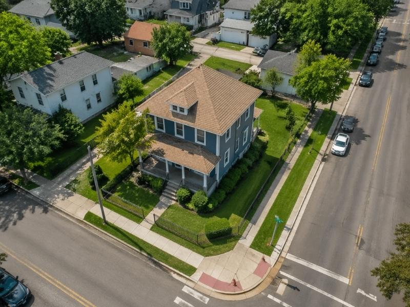
Aerial view of a residential corner lot showing property boundaries and lot layout in Daphne, Alabama

Boundary survey cost factors matter more than most developers think. A cheap survey can turn expensive fast when property lines are unclear, old records conflict, or missing markers slow the work down.

Many projects run into delays because the survey work was treated like a simple box to check. That mistake costs time and money.

This guide explains what affects boundary survey pricing, what can increase costs, and what developers should review before ordering a survey.

Why Boundary Survey Cost Factors Change From Property to Property

No two parcels are alike.

Some sites are simple and open. Others have thick trees, old fences, missing pins, or bad legal descriptions. Those details affect the amount of work needed in the field and office.

A flat, cleared parcel may cost much less than wooded land with old deeds and unclear corners.

Property Size Affects Survey Cost

Larger parcels usually take more time to survey.

The crew may need to:

  • Walk longer distances
  • Search for more corners
  • Review more records
  • Set additional markers

Large tracts with streams, wooded areas, or uneven terrain can also slow field work.

Still, size alone does not control the final price. A smaller parcel with legal issues can cost more than a larger clean site.

Old Deeds and Missing Records Increase Work

Some properties have deed records that go back decades.

Old descriptions may include:

  • Broken measurements
  • Missing distances
  • Outdated landmarks
  • Conflicting property calls

That creates extra research work.

Surveyors may need to compare neighboring deeds, subdivision plats, and county records before confirming the boundary lines.

Developers often underestimate this part of the process.

Boundary Survey Cost Factors Linked to Terrain

Land conditions matter.

Heavy brush, wetlands, standing water, and steep grades make surveys harder to complete. Crews move slower in rough conditions and may need additional equipment.

Thick vegetation is a common issue on undeveloped land.

If crews cannot clearly access corners or lines, clearing may be needed before work begins.

Existing Improvements Can Create More Work

Buildings, fences, driveways, and retaining walls affect the survey process.

Surveyors may need to check whether those improvements cross property lines or enter easements. Accurate land boundary mapping helps identify these issues before construction moves forward. 

That takes extra measurements and reviews.

Older fences create problems often. Many property owners assume fences follow legal boundaries. Some do not.

Corner Marker Problems Raise Costs

Missing property corners are a major factor in boundary survey pricing.

If original markers cannot be found, surveyors must gather evidence from nearby properties and legal records to re-establish the corners properly.

That process takes time.

Damaged markers also create issues. Some become buried, bent, or moved during construction work over the years.

Easements Can Complicate the Survey

Utility easements affect development plans.

Surveyors may need to locate:

  • Drainage easements
  • Utility corridors
  • Access easements
  • Shared drive agreements

Some easements appear clearly in records. Others require deeper title research.

Developers should review easements early before finalizing site plans.

Subdivision Age Matters

Older subdivisions sometimes contain survey problems that newer developments avoid.

Past work may have relied on older equipment or less detailed mapping standards. Over time, monuments may shift or disappear.

Lot dimensions may also conflict between recorded plats and field evidence.

That creates more office review and field verification.

Construction Pressure Can Increase Survey Costs

Rush jobs usually cost more.

Developers sometimes wait until permits are near approval before ordering surveys. That compresses the schedule and creates pressure on field crews.

Fast turnaround requests may require overtime scheduling or priority processing.

Planning ahead helps reduce that problem.

Access Problems Slow the Work

Some sites are difficult to reach.

Locked gates, standing water, nearby construction, or blocked access routes can delay field crews.

Developers should make sure surveyors can safely reach all parts of the property before work begins.

Simple access problems waste valuable field time.

How Developers Can Reduce Survey Delays and Extra Costs

Good preparation helps.

Before ordering a survey:

Gather Existing Documents

Provide:

  • Deeds
  • Prior surveys
  • Title reports
  • Site plans
  • Recorded plats

Good records reduce research time.

Walk the Site Early

Developers should inspect the parcel before work begins.

Look for:

  • Old fences
  • Encroachments
  • Standing water
  • Heavy brush
  • Access concerns

Early planning avoids surprises.

Order Surveys Before Final Design Work

Waiting too long creates problems.

Boundary information should be confirmed before major engineering or layout work begins.

Bad property data can affect drainage plans, parking layouts, setbacks, and utility placement.

Common Mistakes Developers Make

Choosing Only the Lowest Price

Cheap surveys can create expensive delays later.

Low pricing sometimes means limited research or incomplete field checks.

A rushed survey can miss important boundary evidence.

Ignoring Neighboring Encroachments

Encroachments happen often.

Sheds, fences, driveways, and utility lines sometimes cross property lines without anyone realizing it.

Those issues should be identified early.

Assuming GIS Maps Are Accurate

Online parcel maps are useful for reference only.

They are not legal boundary documents.

Developers should never rely on county GIS maps for construction decisions.

Planning Ahead Saves Time and Money 

Boundary survey cost factors depend on more than acreage. Terrain, records, missing corners, easements, and site conditions all affect pricing and project timelines.

Developers who plan early usually avoid the worst delays.

A solid boundary survey helps protect the project before grading, design, and construction begin.

Frequently Asked Questions

What affects the cost of a boundary survey the most?

Property size, terrain, missing corner markers, old deed records, and difficult access often affect pricing the most.

Can old fences change legal property lines?

Not always. A fence location does not automatically define the legal boundary.

Why do missing property corners increase survey costs?

Surveyors must gather evidence and review records to re-establish missing corners correctly.

Are online property maps legally accurate?

No. GIS maps are reference tools and should not replace a professional boundary survey.

When should developers order a boundary survey?

Early in the planning phase. Waiting too long can delay engineering, permits, and construction.
Posted in land surveying | Tagged boundary survey, boundary surveying daphne al

Do You Need a Topographic Survey Before Adding a Pool, Deck, and Extensions to Your Home?

Daphne Land Surveying Posted on May 22, 2026 by AdminDaphneLSMay 15, 2026
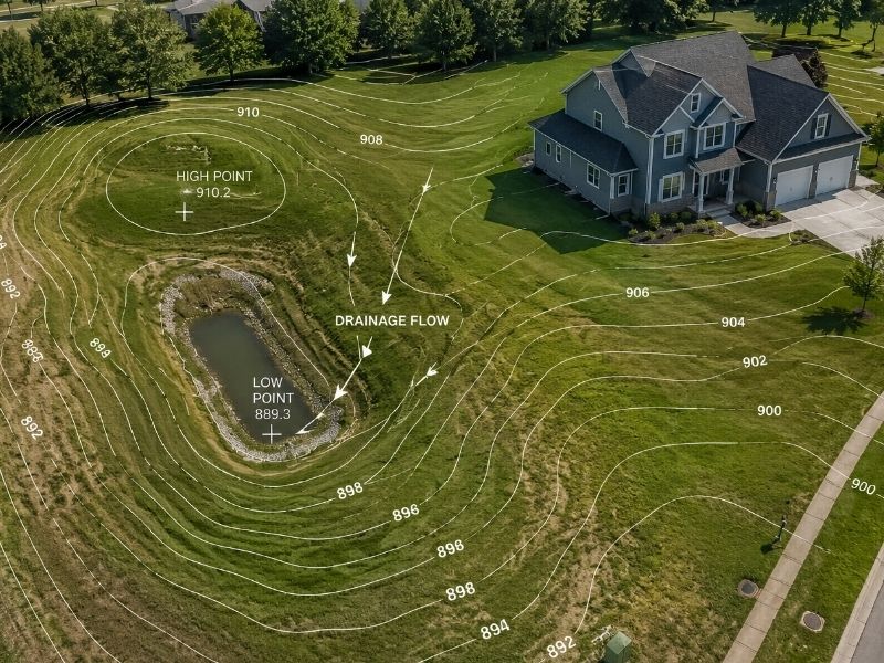
Aerial view of a residential property topographic survey showing contour lines, elevation points, and drainage flow patterns

Most permit rejections come down to one thing: missing site data. A contractor estimates grades by eye. A designer draws plans without knowing where the drainage goes. Then the permit office kicks it back. Or worse, construction starts and water runs the wrong way.

A topographic survey stops that before it starts. For pools, decks and home additions, it’s often the difference between a smooth approval and an expensive rework.

What Is a Topographic Survey?

A topographic survey maps the physical features of your property. It records ground elevations at regular intervals across the site. It also picks up existing structures, trees, drainage features, retaining walls and utility markers.

The output is a contour map. It shows the shape of the land in detail. Architects and engineers use it to design structures that work with the terrain, not against it.

It’s different from a boundary survey. A boundary survey tells you where your property lines are. A topographic survey tells you what the land actually looks like.

You often need both.

When Do You Actually Need One?

More often than most homeowners expect. Whether you need one depends on your project type, your local council or municipal requirements and the complexity of your site.

Adding a Pool

Pool installations almost always need a topographic survey. Excavation depth, water drainage, equipment pad placement and fence setbacks all depend on accurate ground levels.

A pool built on sloped land without proper survey data can drain toward the house. Retaining walls get undersized. Equipment pads end up in the wrong spot. Those mistakes cost far more to fix after the fact than a survey costs upfront.

Most pool permits require a site plan with existing and finished ground levels. A topo survey produces exactly that.

Building a Deck

Decks on flat land may not need a full topographic survey. But decks on sloped or irregular sites almost always do.

A structural engineer needs accurate fall data to design footings correctly. Too steep a slope without proper footing depth causes settlement. Decks that look level on day one can shift within a few years on poorly surveyed sites.

If your deck sits more than 600 millimeters above natural ground level, check your local regulations. Many jurisdictions require engineering certification, and that starts with a topo survey.

Home Additions and Extensions

Ground floor extensions need finished floor levels that tie into the existing structure. That requires knowing the existing site levels first. A survey gives the designer exact data to work from.

It also flags drainage issues before they become your problem. If the addition changes how water flows across the property, your council may require a stormwater management plan. That plan needs survey-grade elevation data.

What a Topo Survey Shows That Other Surveys Don’t

Boundary surveys locate your title pegs. They don’t tell you how steep the backyard is or where stormwater pools after heavy rain.

A topographic survey shows:

  • Ground contours at 200mm to 500mm intervals (or finer on request)
  • Spot levels at key points: doorways, slab edges, drainage grates and low points
  • Existing structures, fences and built features
  • Trees with trunk diameter and canopy spread
  • Overhead and underground service indicators

That data lets your designer model how water moves across the site. It lets your engineer size footings correctly. And it gives your certifier what they need to approve the project.

Without it, everyone is guessing.

What Happens If You Skip It?

Some projects get through without one. But the risk is real.

Drainage problems are the most common outcome. Water that should sheet away from the house ends up pooling near footings. That causes concrete movement, damp walls and long-term structural damage.

Permit delays are the second issue. Many councils will not accept a development application without survey data attached. You find out at submission, not before.

The third problem is contractor disputes. When site levels haven’t been surveyed, builders estimate cuts and fills on site. Those estimates often don’t match the designer’s assumptions. The gap becomes a variation cost, and it comes out of your pocket.

A topographic survey typically costs between $800 and $2,500 for a residential site, depending on size and complexity. That’s a small number compared to a drainage rework or a stalled permit.

How to Get a Topographic Survey

Hire a licensed surveyor. Look for a cadastral or engineering surveyor with residential experience in your area.

Give them the following:

  • Your property address and certificate of title
  • A copy of any existing plans if available
  • The scope of your project so they know what level of detail you need

Survey turnaround is typically 5 to 10 business days from site visit to final deliverable. The output should be a CAD file (.dwg or .dxf) that your designer can work directly from. Ask for it in that format, not just a PDF.

If you’re also getting a boundary survey done, combine both into one engagement. Most surveyors can do both at the same time and the cost savings are worth it.

Frequently Asked Questions

Is a topographic survey required by law for home additions?

It depends on your local authority. Many councils require survey data as part of a development application for pools, decks over a certain height and ground floor extensions. Check with your local planning department before submitting. A surveyor familiar with your area can also confirm exactly what’s required.

Can my builder or draftsperson do the survey instead?

No. Topographic surveys must be carried out by a licensed surveyor. Builders can take site measurements but those aren’t legally certifiable. If your permit requires a survey, the document must come from a registered professional.

How long does a topographic survey take?

A standard residential site takes 1 to 3 hours on site. Data processing and drafting takes another 3 to 7 business days. You should have your final plans within 5 to 10 business days from the site visit.

What’s the difference between a topographic survey and a feature survey?

They’re often the same thing. “Feature and level survey” is the common term in many regions. It captures both the physical features of the site (structures, trees, fences) and the ground levels. Some surveyors call it a topographic survey. Others call it a feature survey. Ask what’s included in the scope before you confirm.

Do I need a new survey if I already have one from when I bought the property?

Maybe not. If the survey is recent (within 3 to 5 years) and no major works have been done since, it may still be usable. But if there’s been excavation, new construction or significant landscaping, you’ll likely need an updated survey. Show your designer the existing one first and let them confirm whether it’s sufficient.

Posted in land surveying | Tagged topographic survey

LiDAR Mapping for Flood Zone Analysis: A Developer’s Practical Guide

Daphne Land Surveying Posted on May 20, 2026 by AdminDaphneLSMay 15, 2026
Drone performing LiDAR mapping over a development site with elevation data and terrain visualization for flood zone analysis

Floods don’t care about property values. They follow elevation. And if your site data is wrong by even half a meter, your flood model is wrong too.

That’s the core problem with traditional surveys over large parcels. They’re slow, expensive, and can miss subtle terrain features that determine where water goes. LiDAR fixes that. It gives you dense, accurate elevation data across wide areas, fast. For developers doing flood zone analysis, it’s now the baseline standard, not a premium option.

Here’s what you need to know to use it properly.

What Is LiDAR, and Why Does It Matter for Flood Analysis?

LiDAR mapping works by firing millions of laser pulses at the ground from an aircraft or drone. Each pulse bounces back. The system records the return time and calculates the exact distance to the surface. LiDAR stands for Light Detection and Ranging. An aircraft or drone fires millions of laser pulses at the ground. Each pulse bounces back. The system records the return time and calculates the exact distance to the surface.

The output is a point cloud: a dense 3D map made of hundreds of millions of individual data points. Each point has an X coordinate, a Y coordinate, and a Z coordinate (elevation).

For flood analysis, elevation is the variable that matters most. A 20-centimeter error in a DEM can shift a flood boundary by hundreds of meters on flat terrain. LiDAR reduces that error to 10 centimeters or better under standard airborne conditions.

How LiDAR Data Gets Used in Flood Modeling

Step 1: Point Cloud to Digital Elevation Model (DEM)

Raw point clouds are processed into a Digital Elevation Model. A DEM strips out trees, buildings, and vehicles using classification algorithms. What’s left is a bare-earth surface.

That bare-earth grid feeds directly into hydraulic simulation software. Programs like HEC-RAS, TUFLOW, and MIKE FLOOD use DEMs to predict where water flows, how deep it gets, and how long it sits.

The finer the DEM resolution, the better the flood model. A 1-meter DEM is solid for most site-level work. A 25-centimeter DEM is better for drainage infrastructure design.

Step 2: Identifying Flow Paths and Problem Areas

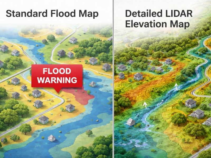
LiDAR reveals what standard topo maps can’t: subtle depressions, natural drainage channels, and culvert inlets. Water always follows the lowest path. LiDAR makes those paths visible before construction starts.

A site that looks flat on a 5-meter contour map might have a 40-centimeter drainage swale running through it. That changes your grading plan entirely.

Step 3: Pre- vs. Post-Development Comparison

Developers use LiDAR-based models to compare existing versus proposed conditions. If you add 8,000 square meters of impervious surface (rooftops, paving, car parks), runoff volume increases. LiDAR lets engineers model exactly where that extra water goes before a single trench is dug.

Regulatory bodies in many jurisdictions now require this comparison as part of the planning approval process.

LiDAR mapping comparison showing a standard flood map beside a detailed elevation map with terrain and water flow analysis

LiDAR vs. Other Survey Methods

Airborne LiDAR is the workhorse for regional flood analysis. It covers hundreds of square kilometers per day with a vertical accuracy of 10 to 15 centimeters. That’s fast enough and precise enough for most flood modeling work across large parcels or catchment areas.

Drone LiDAR trades coverage for detail. It covers 1 to 5 square kilometers per day, but accuracy tightens to 2 to 5 centimeters. That level of resolution works well for site-level drainage design where small elevation differences actually matter.

Ground surveys are the slowest option at 5 to 10 hectares per day. The tradeoff is sub-centimeter accuracy. Use them for small areas, legal boundary work, or to verify benchmarks that other methods flagged as uncertain.

Photogrammetry sits in a different category. It’s fast and works from aircraft or drones, but accuracy drops under tree canopy. Expect 5 to 15 centimeters on open terrain. Avoid it where dense vegetation covers the site.

For broad flood zone analysis, airborne LiDAR is the right starting point. For detailed drainage design at the site level, drone LiDAR or a targeted ground survey fills the gaps.

Where to Get LiDAR Data

You don’t always need to commission a new survey. Many governments publish open LiDAR datasets:

  • United States: USGS 3DEP (3D Elevation Program) covers most of the country with 1-meter resolution data. Access it at apps.nationalmap.gov.
  • United Kingdom: The Environment Agency publishes 1-meter and 25-centimeter LiDAR for most of England at no cost.
  • Australia: Geoscience Australia’s ELVIS platform provides elevation data for large parts of the country.
  • European Union: The Copernicus Land Monitoring Service offers 10-meter and 25-meter DEMs across Europe.

Check two things before downloading: collection date and point density. Data collected before major development or after a significant flood event may not reflect current ground conditions. Aim for data collected within the last 3 to 5 years for active development sites.

What Developers Should Ask Before Using LiDAR Data

Before your engineer submits a flood report built on LiDAR, ask these four questions:

  1. What is the vertical accuracy of this dataset? You want 15 centimeters or better for flood modeling.
  2. When was the data collected? Anything older than 5 years on a developed site warrants field verification.
  3. Has it been ground-truthed? Benchmark checks against known survey points confirm the data is reliable.
  4. What hydraulic model was used? HEC-RAS, TUFLOW, and MIKE FLOOD are industry-standard. Proprietary or undocumented tools are a red flag.

Those questions protect you. A flood report that looks polished but uses poor input data will cost you far more later.

What LiDAR Cannot Do

LiDAR maps terrain. It doesn’t map:

  • Underground pipe networks and drainage infrastructure
  • Soil permeability and infiltration rates
  • Future climate scenarios or changing rainfall intensities
  • Legally designated flood zones (those come from regulatory authorities)

Flood risk is not terrain alone. A complete analysis combines LiDAR-derived DEMs with stormwater records, soil surveys, drainage plans and local authority flood maps. LiDAR is the foundation. It’s not the whole structure.

Frequently Asked Questions

Is LiDAR-derived elevation data accepted for regulatory flood assessments?

Yes, in most jurisdictions. Many planning and drainage authorities accept LiDAR data if it meets their published accuracy standards. Confirm acceptance with your local authority before commissioning a report. Some jurisdictions require a licensed surveyor to certify the data before submission.

How much does a LiDAR survey cost?

Airborne LiDAR surveys typically range from $500 to $1,500 per square kilometer. Drone-based surveys for smaller sites run between $2,000 and $10,000, depending on area, resolution, and deliverable specs. Free government datasets are worth checking first.

How old is too old for LiDAR data?

For undisturbed rural land, data 5 to 7 years old is usually acceptable. For land near active construction, new drainage works, or recent storm events, aim for data collected within the last 2 to 3 years. When in doubt, commission spot ground checks at key drainage points.

Can LiDAR see through tree canopy?

Partially. Airborne LiDAR fires multiple pulses per second. Some pulses pass through gaps in the canopy and return a ground hit. Processing software uses these ground returns to build the bare-earth DEM. Dense tropical or coniferous canopy reduces ground hit density, so accuracy drops slightly in heavily forested areas.

Do I need a licensed surveyor to use publicly available LiDAR data?

For early-stage feasibility and desktop analysis, no. For documents submitted to regulatory bodies (flood certificates, drainage reports, planning applications), yes. Licensed professionals are required to certify elevation data for legal purposes in most jurisdictions.

Posted in land surveying | Tagged Land Surveying, lidar mapping

Post navigation

← Older posts
Newer posts →

Contact Us Now

    Categories

    • alta survey
    • blog
    • Boundary survey
    • construction staking
    • elevation certificate
    • flooding
    • GPS
    • land surveying
    • land surveyor
    • LiDAR mapping
    • Topo Survey
    © Copyright Daphne Land Surveying
    Daphne, Alabama 36526
    Phone: (251) 270-4140

    Privacy Policy | Terms of Use

    Web Development and SEO by:
    AuburnBusiness.com

    The owner of this website, USA Surveying & Engineering, LLC., provides coordination of professional land surveying and engineering services in all 50 states. The professional surveying and engineering services provided to you will be conducted by fully licensed professionals in your state.

    Privacy Policy
    ↑